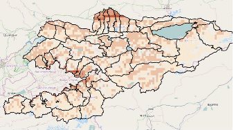
KYRGYZSTAN SPATIAL FEATURED AS A CUTTING-EDGE TOP SOLUTION THAT SAVE LIVES IN HUMANITARIAN RESPONSE AND DISASTER RELIEF
In April 2015, the University of Central Asia’s Institute of Public Policy and Administration in collaboration with the International Food Policy Research Institute (IFPRI) launched Kyrgyzstan Spatial, a new online mapping platform.
Kyrgyzstan Spatial incorporates innovative mapping concepts and technology using data from a wide range of sources and for a wide range of use. It enables users to visualize areas most vulnerable to food insecurity and target policies and research where they are most needed. The tool can accommodate any number of layers at national, sub-national and pixel levels, show a dynamic display of indicators over time, and provides the ability to download and print maps and graphs.
The launch of Kyrgyzstan Spatial was a success in Kyrgyzstan and the region as a whole with more and more people expressing interest in using it. This innovative tool was featured at the top of the list, as a cutting-edge top technology in Aid & International Development Forum (AIDF)’s report on ‘Top Solutions That Save Lives in Humanitarian Response and Disaster Relief’. AIDF, the Aid & International Development Forum, a London based organization is the world leading forum specializing in disaster relief, food security and water security, leading the platform for knowledge exchange between NGOs, UN agencies, governments and the private sector worldwide.

Leave a Reply